NCERT Solutions for Geography, Chapter 2 – Physical Features of India
Intext Questions
On Page 11
Question 1. Find out the names of the glaciers and passes that lie in the Great Himalayas.
Answer
The names of the glaciers that lie in Great Himalayas are
(a) Siachen Glacier – Jammu and Kashmir
(b) Godwin Glacier – Jammu and Kashmir
(c) Gangotri Glacier – Uttarakhand
(d) Yamunotri Glacier – Uttarakhand
Passes that lie in the Great Himalayas
Himachal Pradesh Rohtang Pass, Karakoram Pass, Rupin Pass
Sikkim Nathu La, Jelep La
Uttarakhand Mohan Pass
Question 2. Find out the name of the states where highest peaks are located.
Answer States where highest peaks are located are
(a) Jammu and Kashmir (Nanga Parbat)
(b) Sikkim (Kanchenjunga)
(c) Uttarakhand (Nanda Devi, Kamet)
Question 3. Find out the location of Mussoorie, Nainital, Ranikhet from your atlas and also name the state where they are located.
Answer All the three towns are in the state of Uttarakhand in the range called lesser Himalaya or Himachal.
Page 15, 16 Exercises
Question 1. Choose the right answer from the four alternatives given below.
(i) A landmass bounded by sea on three sides in referred to as
(a) coast
(b) island
(c) peninsula
(d) None of these
Answer (c)
(ii) Mountain ranges in the eastern part of India forming its boundary with Myanmar are collectively called as
(a) Himachal
(b) Uttarakhand
(c) Purvanchal
(d) None of these
Answer (c)
(iii) The Western coastal strip, South of Goa is referred to as
(a) Coromandal
(b) Konkan
(c) Kannad
(d) Northern Circar
Answer (c)
(iv) The highest peak in the Eastern Ghats is
(a) Anai Mudi
(b) Kanchenjunga
(c) Mahendragiri
(d) Khasi
Answer (c)
Question 2. Answer the following questions briefly
(i) What are tectonic plates?
Answer The convectional currents below the Earth’s crust split the crust into a number of pieces. These pieces are called tecton plates. e.g., Eurasia plate, Indo Australian plate etc.
(ii) Which continents of today were part of the Gondwana land?
Answer The Gondwana land included India, Australia, South Alho and South America as one single land mass.
(iii) What is the Bhabar?
Answer Bhabar is a narrow belt of land about 8 to 16 km wide and covered with pebbles deposited by the rivers and lying parallel to the slopes of the Shiwaliks.
(iv) Name the three major divisions of the Himalayas from north to south.
Answer The 3 major divisions of the Himalayas from North to South are as follows
(a) The Great or Inner Himalayas or the Himadri It is a continuos range consisting of the highest peaks.
(b) Himachal or Lesser Himalayas The range lying to the South of the Himadri is known as Himachal or Lesser Himalayas.
(c) Shiwaliks The outermost range of the Himalayas is known as the Shiwaliks. These are the foothill ranges and represent the southernmost division of the Himalayas.
(v) Which plateaus lies between the Aravali and the Vindhyan ranges?
Answer Malwa plateau lies between the Aravali and the Vindhyan ranges.
(vi) Name of the Island group of India having coral Vindhyan
Answer Lakshadweep Islands are composed of small coral islands.
Question 3. Distinguish between
(i) Converging and diverging tetonic plates.
Answer Difference between Converging plates and Diverging plates.
| Converging Tetonic Plates | Diverging Tetonic Plates |
| The plates that come towards each other and form a convergent boundary. | The plates that move away from each other and form divergent boundary. |
(ii) Bhangar and Khadar.
Answer Differences between Bhangar and Khadar.
| Bhangar | Khadar |
| (a) Bhangar is cold alluvial soil. | (a) Khadar is new alluvial soil. |
| (b) Bhanger soil is found away from the river. | (b) Khadar is found near the river basin. |
| (c) Bhangar is less fertile. | (c) Khadar is very fertile. |
| (d) It contains calcareous deposits (d) This soil is fine grained. locally known as Kankar. | (d) The soil is fine grained. |
| (e) The soil is dark in colour. | (e) The soil is light in colour. |
| The Eastern Ghats | The Western Ghats |
| (a) The Eastern ghats mark the eastern edge of the Deccan plateau. | (a) The Western ghat mark the western edge of the Deccan plateau. |
| (b) They are discontinuous and irregular and dissected by rivers draining into the Bay of Bengal. | (b) They are continuous and can be crossed through passes only. |
| (c) They lie parallel to the eastern coast along the Arabian Sea. | (c) The Western Ghats lie parallel to the west coast along the Arabian Sea. |
| (d) The highest mountain is Mahendragiri with a height of 1,501 metres. | (d) The highest peak is Anai Mudi with a height of 2,695 metres. |
| (e) Their average height is 600 metres. | (e) Their average height is1,600 metres. |
Question 4. Describe how the Himalayas were formed.
(f) The Himalayas represent a youthful topography with high peaks, deep valleys and fast following rivers.
(i) The Himalayan mountains
(iii) The Peninsular plateau
(v) The Coastal plains
(ii) The Northern plains
(iv) The Indian desert
(vi) The islandsPhysical Features of IndiaContrast between the Himalayan region and the Peninsular plateau
| The Himalayan Region | The Peninsular Plateau |
| (a) Formed by folding process due to collision of the Indo Australia plate with the Eurasian plate. | (a) Formed due to the breaking and drifting of Gondwana land. |
| (b) Himalayas made up of sedimentary rocks. | (b) Plateau contains igneous and metamorphic rocks. |
| (c) Himalayan mountains form an unstable zone. | (c) Considered to be one of the most stable land blocks. |
| d) Himalayas are the most recent landforms. | (d) The Deccan plateau is one of the most ancient landmasses. |
| (e) The average height of Himalayas is 6,000 metres. | (e) The average height of the plateau is 900 metres. |
| (f) The Himalayas lack minerals. | (f) The plateau is a storehouse of minerals. |
| (g) Perenial rivers originate in the Himalayas. |
(g) Peninsular rivers are seasonal. |
Question 6. Give an account of the Northern plains of India.
h) The Brahmaputra Plain to the East of the Ganga plains lies the Brahmaputra plain covering the areas of Assam and Arunachal Pradesh.
(i) The Indian Desert
(ii) The Island Groups of India
(ii) The Central Highlands
(i) The Indian Desert
2) Earlier, they were known as Laccadive, Minicoy and Amindive. In 1973, these were renamed as the Lakshadweep.
3) They cover a small area of 32 sq km.
4) Kavaratti Island is the administrative headquarters of Lakshadweep.
5) This island group has a great diversity of flora and fauna.
6) The Pitti Island, which is uninhabited, has a bird sanctuary.
(b) Andaman and Nicobar Islands
1) The elongated chain of islands located in the Bay of Bengal extending from north to south are the Andaman and Nicobar Islands.
2) They are bigger in size and more numerous and scattered than the Lakshadweep Islands.
3) The entire group of islands is divided into two broad categories, the Andaman in the north and Nicobar in the south.
4) It is believed that these islands are an elevated portion of the submarine mountains.
5) These islands are of great – strategic importance for the country.
They have great diversity of flora and fauna.
6) These islands lie close to the equator experience equatorial climate and have thick forest cover.
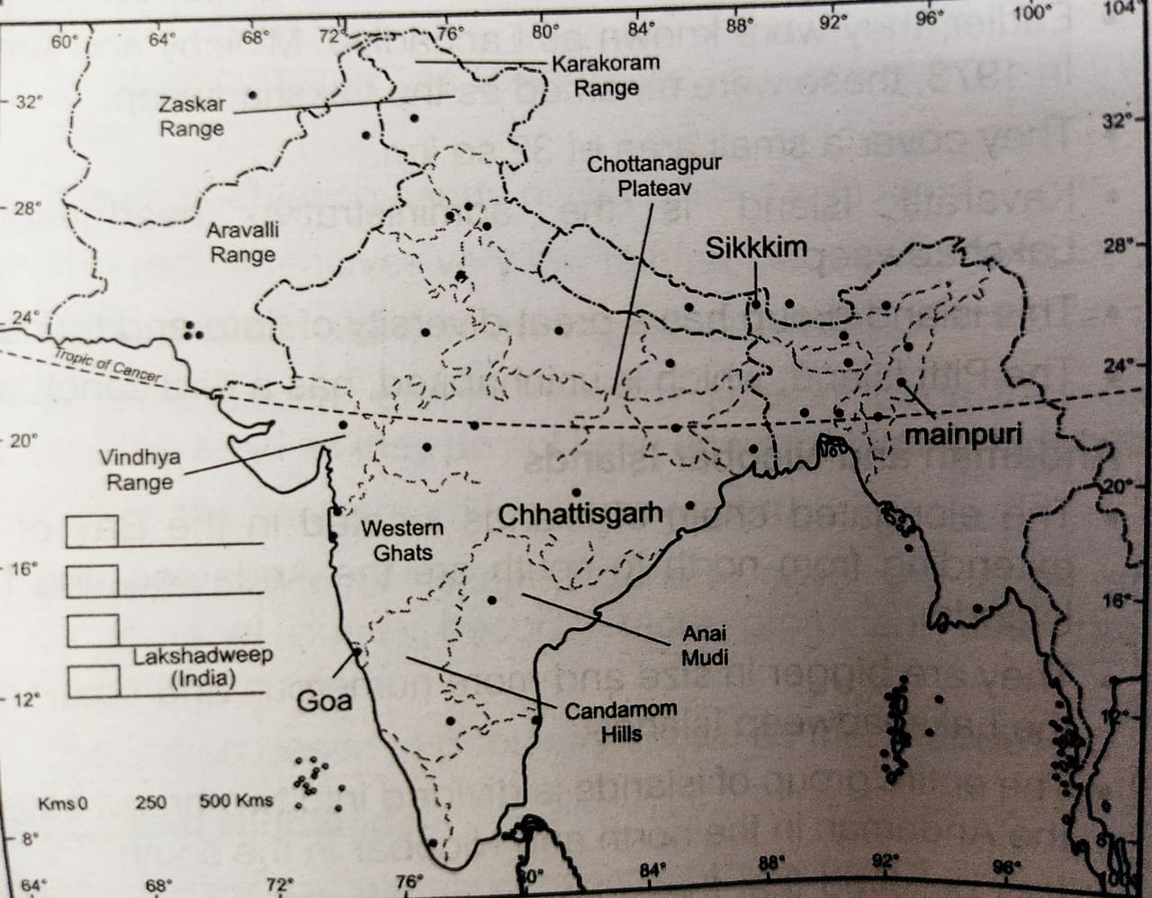
Map Skills
On an outline map of India show the following.
(i) Mountain and Hill Ranges The Karakoram, the Zaskar, the Patkai Bum, the Jaintia, the Vindhya range, the Aravali and the Cardamom hills.
(ii) Peaks K2, Kanchenjunga, Nanga Parbat and the Anai Mudi.
(iii) Plateaus Chhotanagpur and Malwa.
(iv) The Indian Desert, Western Ghats, Lakshadweep Islands.
Project/ Activity
Locate the peaks, passes, ranges , plateau hills and duns hidden in the puzzle. Try to find where these features are located.You may star your search horizontally vertically or diagonally.

1. Nathula
4. Kanchenjunga
7. Patli
2. Cardamom
3. Garo
5. Anaimudi
6. Everest
1. Chottanagpur
4. Jaintia
7. Shipkila
10. Sahyadri
2. Aravali
3. Konkan
5. Malwa
6. Nilgirl
9. Bomdila
8. Vindhya
11. Satpura (this one is from bottom to top)
Leave a Reply